Cavalry Tunnel: The Secret Almost Abandoned Tunnel under a London Railway Line
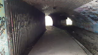
Nowhere to be found on Google Maps, running parallel to the River Crane, the Cavalry Tunnel lies dark and abandoned under the train line between Whitton and Feltham. And despite the unclear access rights the tunnel is relatively heavily used by the general public with no physical obstructions which stop access. The tunnel is split into two parts; the most used paved section connecting either side of the train line, and the abandoned pitch black fly tipper's heaven with a tantalising door at the end.
The Used Section

Despite being almost abandoned the used section has unnaturally high footfall primarily because the nearest crossing of the railway line is 0.6 miles away (by the crow flies) on both sides. To get to the southern entrance to the tunnel you should travel; along the River Crane, through Pevensey Road Nature Reserve, or through Leitrim Park. The tunnel itself is then located on the western side of the mound and the entrance is blue in colour with heavy amounts of graffiti. From the north the tunnel is much easier to access as the River Crane travels parallel to the tunnel under the railway line and the footpath consequently follows the river's western bank.
The Abandoned Section

Located south of the useful section and pitch black (the whole Cavalry Tunnel has no lighting but the used section has sunlight to illuminate the way) the abandoned mild URBEX of a tunnel awaits. At 90 metres long this section is filled with uneven ground and has various random objects scattered on the ground. Also in the "path" in the centre of the tunnel are some nontrivial pieces of water to navigate but the exit is clear as it shines bright from the daylight on the other side. The light comes from a small doorway leading to presumably the mound on top of the pair of tunnels.

The London LOOP shortcut
Before the shortcut you might want to know what the London LOOP is. Well the London Outer Orbital Path (yes London is technically repeated like in PIN number) is described as the "M25 for walkers". The 150 mile path runs in a clockwise circle from Erith on the Thames' southern bank to Purfleet which is almost directly opposite on the Northern bank. There is no ability to cross the river at the start and end of the London LOOP so technically it isn't even a loop.
The Cavalry Tunnel provides a substantial shortcut on the route of the London LOOP with the official route and up to date route showing the way between the sections of River Crane to the north and the south is via Hanworth Road to cross the railway line and then Hounslow Heath. The Cavalry Tunnel is, however, shown as an alternative route on the up-to-date route.


Comments
Post a Comment