Nanjizal Beach: The Caribbean Cove in Cornwall

Also known as Mill Bay, Nanjizal is located on the south coast of Cornwall between Porthcurno and Land's End (the westernmost point in mainland England). Nanjizal has no road access with only a narrow private track coming close to the beach, this makes it an elusive location to access with the nearest car park over a mile away.
What is at Nanjizal

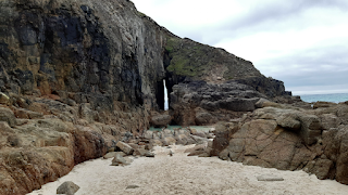
Nanjizal not only has a beautifully sandy beach but also a gorgeous waterfall and some striking caves. With them being best viewed from the cove but also have good views from the approach. On either side of Nanjizal there are cliffs with the beach located several metres below the South West Coast Path. And the idyllic landscapes of the area slowly change and evolve as you descend into Nanjizal. With access being past some ponies (well they were there when I went) and some steps onto a cluster of rocks with the sandy section of the beach a few metres away.
Accessing Nanjizal
As the cove is at least a mile from the nearest car park it is important that you know how to get to the phenomenal features of Nanjizal. You should come along the South West Coast Path either from the north or the south.
Access From the North
Accessing Nanjizal from the north is done by parking at Land's End and walking about 1.5 miles along the coast following the South West Coast Path with some stunning cliff top views of the Atlantic Ocean. Despite only being 1.5 miles the terrain is not the easiest with some large changes in elevation.
Access From the South

|
| Access from the south |
Access from the south is a little harder than the north as the carpark at Porthgwarra is accessed by a narrow single track Cornish road. The facilities at Porthgwarra are significantly fewer than at Land's End and the walk is slightly longer at a minimum of 1.6 miles. This walk can be done by following the South West Coast Path but as this religiously follows the coast it is longer at just under 2 miles. With the most efficient route leaving the car park along the road to the west of the village then travelling almost directly north to Nanjizal.
The Day Marks

When accessing Nanjizal from the south along the South West Coast Path, there are stunning cliff top vistas, a National Coastwatch Institution station, and two odd obelisks. These two day marks, one red and the other black and white, are used to warn ships of the Runnel Stone. The two day marks are positioned so that when viewed from the sea the marks have the potential to obscure each other. And when the red mark fully obscures the black and white mark your boat is on top of the Runnel Stone which consequently means you're in trouble.


Comments
Post a Comment